")
1953 · (West Virginia)
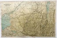
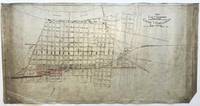
(West Virginia): Nicholas, Fayette, and Greenbrier Railroad Company , 1953. Map. Very Good. One Page,Folded. Blueprint map measuring 27" h x 39 1/2" w, scale 1" = 2 miles, approx. Profile scale: Hor. 1' = 4 mi., Ver. 1" = 600 feet. Originally printed Jan. 18, 1932, this map went through 15 revisions in the 30s, 40s, and 19503, with this revised printing dated Mar. 17, 1953. Very Good, 1" tear bottom edge at folder, a few scattered smaller edge tears and small chips, uneven fading to the map due to being partially folded. The NICHOLAS, FAYETTE, AND GREENBRIER RAILROAD was formed in 1929, named after the three counties it served in the New River coal fields of West Virginia, and was controlled by the C & O and NYC Railroads. A RARE and original railroad company blueprint map, highly suited for framing and will be shipped loosely rolled in sturdy mailing tube. . (Inventory #: 010250)