Carousel content with 1 slides.
A carousel is a rotating set of images, rotation stops on keyboard focus on carousel tab controls or hovering the mouse pointer over images. Use the tabs or the previous and next buttons to change the displayed slide.

-
Slide 1:
-
 Slide 2: no title
 -
 Slide 3: no title
 -
 Slide 4: no title
 -
 Slide 5: no title
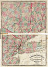
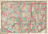
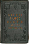
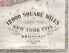
1866 · New York
by LLOYD, H.H.
New York: H.H. Lloyd, 1866. Rich full period color. On two sheets that form one map, 36½ x 50½ inches, folding into gilt-stamped dark green cloth covers. First edition. This is an exceedingly detailed wall map in pocket format, that shows the environs of New York City on a scale of two and one-half miles to the inch. The map extends from Long Branch on the Jersey Shore in the south to Rhinebeck in the Hudson Valley in the north; and from Patchogue on Long Island in the east to Trenton, New Jersey in the west. This may be the same as Rumsey 3212 (1867), but with a different title: "An intense map of the region around New York, intensely colored and dense (truncated)

