Carousel content with 1 slides.
A carousel is a rotating set of images, rotation stops on keyboard focus on carousel tab controls or hovering the mouse pointer over images. Use the tabs or the previous and next buttons to change the displayed slide.

-
 Slide 1:
-
 Slide 2: no title
 -
 Slide 3: no title
hardcover
1934 · New York
by SANBORN MAP COMPANY
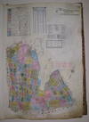
New York: Sanborn Map Company, 1934. hardcover. very good. Atlas. Lithograph with original hand coloring. Massive elephant folio. Decorative calligraphic titles, indices, and key maps. Contains a set of 91 maps along with changes recorded on paste-on correction slips through 1973. Quarter leather binding with gilt title on front and spine. Medium tear to spine of original protective canvas cover.
This volume includes part of Auburndale and Little Neck, the border to Nassau County, Fort Totten, Clearview Golf Course, and the Horace Harding/Clearview Expressways Interchange. The Sanborn map collection consists of a uniform series of large scale (truncated)
This volume includes part of Auburndale and Little Neck, the border to Nassau County, Fort Totten, Clearview Golf Course, and the Horace Harding/Clearview Expressways Interchange. The Sanborn map collection consists of a uniform series of large scale (truncated)