Carousel content with 1 slides.
A carousel is a rotating set of images, rotation stops on keyboard focus on carousel tab controls or hovering the mouse pointer over images. Use the tabs or the previous and next buttons to change the displayed slide.
")
-
 Slide 1:
-
 Slide 2: no title
 -
 Slide 3: no title
 -
 Slide 4: no title
hardcover
1929 · New York
by SANBORN MAP COMPANY
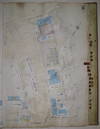
New York: Sanborn Map Company, 1929. hardcover. very good. Atlas. Lithograph with original hand coloring. Massive elephant folio. Decorative calligraphic titles, indices, and key maps. Contains a set of 78 detailed maps of southern Brooklyn along with changes recorded on paste-on correction slips through 1973. Quarter leather binding with gilt title on front and spine. Tear to spine of original protective canvas cover.
This volume includes the new Belt Parkway ("Shore Parkway") and undeveloped waterfront land that is now filled-in parks and piers. The Sanborn map collection consists of a uniform series of large scale maps, dating from 1867 (truncated)
This volume includes the new Belt Parkway ("Shore Parkway") and undeveloped waterfront land that is now filled-in parks and piers. The Sanborn map collection consists of a uniform series of large scale maps, dating from 1867 (truncated)