Carousel content with 1 slides.
A carousel is a rotating set of images, rotation stops on keyboard focus on carousel tab controls or hovering the mouse pointer over images. Use the tabs or the previous and next buttons to change the displayed slide.
")
-
 Slide 1:
-
 Slide 2: no title
 -
 Slide 3: no title
 -
 Slide 4: no title
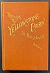
1886 · New York
by Wingate, George W.
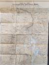
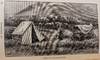
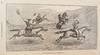
New York: O. Judd Co., David W. Judd, Pres’t., 1886. 8vo. 195 x 125 mm., [7 ¼ x 5 inches]. 250pp., [6pp ads]. Illustrated with a folding map of the terrotory, a wood engraved frontispiece and 20 plates and text illustrations. The folding map has a few splits at the folds, expertly repaired with Japanese tissue. Bound in publisher’s terra cotta cloth with title gilt on upper board and spine. Pocket for map on rear pastedown. Ownership inscription on front pastedown. Near fine copy.
First edition. One of the standard travel books to Yellowstone written for the benefit of others interested in making (truncated)
First edition. One of the standard travel books to Yellowstone written for the benefit of others interested in making (truncated)

