Carousel content with 1 slides.
A carousel is a rotating set of images, rotation stops on keyboard focus on carousel tab controls or hovering the mouse pointer over images. Use the tabs or the previous and next buttons to change the displayed slide.
")
-
 Slide 1:
-
 Slide 2: no title
 -
 Slide 3: no title
 -
 Slide 4: no title
 -
 Slide 5: no title
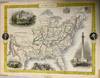
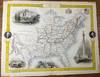
Map
1851 · London & New York
by Tallis, John; Rapkin, John (engraver)
London & New York: John Tallis, 1851. Map. Good. Map. Approx. 11" x 14". Map covers Santa Fe north through the Missouri Territory to Canada and east to the Atlantic. Undated but recorded 1851. Removed from the "The Illustrated Atlas, and Modern History of the World. Geographical, Political, Commercial & Statistical". Published by London by John Tallis & Company, 1851. Some remnants of tape residue at 5 spots on the extreme edges. Folded once. Good condition.
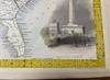
Map is illustrated with small portraits of Washington and Franklin, color vignettes of the Washington Monument, Capitol, a buffalo hunt, and a pioneer scene. West Virginia, (truncated)
Map is illustrated with small portraits of Washington and Franklin, color vignettes of the Washington Monument, Capitol, a buffalo hunt, and a pioneer scene. West Virginia, (truncated)