unbound
1895 · New York
by BIEN, Julius
New York: Julius Bien & Co, 1895. unbound. Map. Color lithograph. Sheet measures 18 1/2" x 29 1/2"
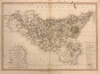
This collection of inset maps relating to the American Civil War's twin Forts Donelson and Henry includes seven images, sketches and maps, of operations between Feb. 4 and Mar. 10, 1862. The insets include "Plan of Fort Henry and its Outworks"; "Plan of Fort Donelson and its Outworks"; "Sketch showing the Relative Positions of Fort Henry and Fort Donelson"; "Military Map of the Country between the Tennessee and Cumberland"; "Fort Donelson and the Positions of the 1st Division During the Siege Feb 12-16, 1862"; and two untitled battlefield sketches. Blue lines for the Union and red for the Confederacy show the geographical location of the various armies. Dates and generals' names are also provided. Situated on the Tennessee and Cumberland Rivers respectively, Union armies attacked from the water at Forts Henry and Donelson and won, securing access to water travel and further weakening the Confederate army's control of the Tennessee River. Beyond this historical information, the map is highly detailed in itself, with cities, capitals, railroads, canals, towns, villages, and forts labeled. The maps appeared as plate XI in "The Atlas to Accompany the Official Records of the Union and Confederate Armies, 1861-1865." Folded as issued. There are a few small tears to the bottom and righthand edges of the sheet that do not affect the image. This map is a wonderful piece that boldly documents American history.
Julius Bien (1826-1909) was an American lithographic printer and cartographer based in New York City. During the course of the second half of the 19th century, he produced thousands of maps for both public and private publishers. Some of his most notable commissions were for the U.S. government, including many geological maps that redefined the cartographic visualization of geology. Bien's prolific output and contributions to the development of chromo-lithography make him one of the most significant map printers of his time. This is a great example of his fine work. (Inventory #: 325255)