1720 · Nuremberg
by HOMANN, Johann Baptist (1664-1724)
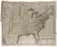
Nuremberg: Johannes Baptista Homann, 1720. Engraved with period outline colour. Image size: 18 3/4 x 22 1/2 inches. Sheet size: 20 1/4 x 24 inches. This striking map by Johann Baptist Homann presents a detailed representation of North and South America, reflecting contemporary cartographic knowledge and cultural interactions in the early 18th century.
This richly detailed map of North and South America, produced by Homann and later corrected by his son Johann Christoph, showcases the evolving understanding of the continents geography in the early 18th century. In this corrected state of the map, California is now depicted as a peninsula rather than an island, and the western coastline extends further north and west, reflecting contemporary explorations. Notable features include a largely speculative region on the northwest coast, and the striking remnants of the "Great Sea of the West," near the Pais de Moozemleck. The map also indicates Indigenous lands, missions, forts, and trading posts, particularly in the American southwest and around the Great Lakes, where French fur traders and the Hudson's Bay Company were active. A prominent, uncoloured title cartouche depicts Indigenous peoples and animals alongside European colonists as well as a vignette illustrating a settlement in the New World. Homann was a prominent German cartographer and engraver, recognized as one of the leading mapmakers of the early 18th century. Born in Oberkammlach, Bavaria, Homann initially trained as a notary before turning to engraving and cartography, quickly establishing his own publishing house in Nuremberg. In 1702, he founded Homann Erben, which became one of the most important map-publishing firms of the period. His work gained widespread acclaim, and he was appointed Geographer to the Emperor in 1715 by Charles VI. Homann's maps are distinguished by their blend of artistic ornamentation and geographic detail, often incorporating celestial elements, allegorical figures, and depictions of natural phenomena. He produced atlases, maps, and globes, and his firm remained influential well into the 19th century under the leadership of his heirs. Following Homann's death in 1724, his son, Johann Christoph Homann, took over the family business, re-engraving many of his father's maps to update geographic information. Christoph further enhanced the firm's reputation by continuing the tradition of high-quality cartographic production, ensuring that the Homann name remained synonymous with excellence in mapmaking. (Inventory #: 12523)