1732 · Amsterdam
by KAEMPFER, Engelbert
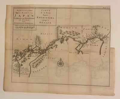
Amsterdam: Herman Uytwerf, 1732. Map. Copper engraving. Image measures 15.5" x 13.25".
This is a scarce 1732 map of the coast along the Hiroshima, Okayama, and Hyogo regions of Japan by Engelbert Kaempfer, issued as part of the French edition of "Histoire Naturelle, Civile, et Ecclesiastique de l'Empire du Japon," published in a three-volume set by Uytwerf in Amsterdam. This map appears in Volume II. The map details the region from the city of Imabari on the northern tip of the Ehime region west as far as Osaka. The Modern day cities of Ako, Aioi, Akashi, Kobe, Amagasaki, Osaka, and Sakai are identified. Features several islands, mountains, cities, and bays illustrated throughout.
The map represents an important example of early cartographic and cultural exchange between Japan and the West. Kaempfer, a German physician and diplomat, traveled to Japan with the Dutch East India Company in the late 17th century during Japan's isolationist Sakoku period. He lived in Nagasaki between September 1690 and October 1692, and twice accompanied the chief of the factory at Deshima on his embassy to Tokyo (Edo). This map describes the third part of the route, covering the sea route from Kurishima to Osaka. This journey was embarked upon once a year by the ambassadors of the Dutch East India Company, and was the only opportunity for foreigners to travel in Japan during this period. The map is in good condition with minor wear along original fold lines.
Kaempfer's first-hand observations led to more precise depictions, including in the northern regions like Kamchatka and Hokkaido (then called Jesso). Despite some geographical distortions, Kaempfer's work greatly influenced Western understanding of Japan and its geography. His History of Japan became an essential reference for European mapmakers, illustrating Japan's provinces, towns, and natural features with unprecedented detail for the time. Later European cartographers, such as Jacques-Nicolas Bellin, published maps of Japan based on Kaempfer's work. The map's historical significance extends beyond cartography, offering insight into Japan's limited interactions with the West under the Tokugawa Shogunate's Sakoku policy. It demonstrates the slow but steady flow of knowledge between Japan and Europe, laying the groundwork for future cross-cultural exchanges. Kaempfer's map was instrumental in expanding Western knowledge of Japan and is considered one of the most important European maps of Japan in the 18th century.
Engelbert Kaempfer (1651-1716) was a German physician, naturalist, and explorer renowned for his extensive travels across Russia, Persia, India, Southeast Asia, and Japan between 1683 and 1693. Born in Lemgo in the Holy Roman Empire, he pursued studies in medicine and natural sciences and later joined the Dutch East India Company as a surgeon, which led him to Japan. During his two-year stay at the Dutch trading post in Deshima, Nagasaki, Kaempfer visited Edo (Tokyo) and studied Japanese culture and geography.
Kaempfer is best known for his posthumously published History of Japan (1727), a foundational work that shaped Western understanding of Japan for over a century. His earlier work, Amoenitatum exoticarum (1712), focused on medical observations and Japanese botany. His maps and writings, compiled and translated by Johann Gaspar Scheuchzer, became influential references for European cartographers and scholars. This is great example of his work. (Inventory #: 324893)