1860
by VERBIEST, Ferdinand
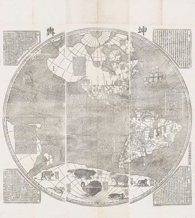
1860. Six sheets, all woodblock-printed on one side, each sheet measuring ca. 1785 x 570 mm., forming two sets of three sheets each, the sets showing the world in two hemispheres. Each set with four large spandrels in corners, with text. Woodcut illus. of animals in the southern polar landmass, a multi-masted trading ship, etc. [Seoul]: colophon dated 1860.
The very rare Korean edition of the famous Verbiest map, first printed in Beijing in 1674 by the Jesuit Ferdinand Verbiest (1623-88). His map, one of the largest woodblock-printed maps, was probably based on the 1648 world map by Blaeu. In 1856, a new issue of the Verbiest map was made in Guangdong, probably from new blocks, presumably to refamiliarize the Chinese with European geography. From a copy of this map, a Korean edition was printed in Seoul, by order of King Cheoljong (1831-64, r. 1849-64), in 1860.
The Chosŏn government’s renewed interest in world maps from China was kindled by a series of military crises in China caused by Western imperial powers in the mid-19th century. In this period, fearing that the Korean peninsula would be next to suffer Western incursions, the Chosŏn government made efforts to introduce new world geographical treatises from China as sources to learn about the situation in China and the ways to cope with Western threats. This period also witnessed a renewed Korean interest in the old Jesuit world maps, as shown in the 1860 official reproduction of Verbiest’s world map, Kun yu quan tu.
The orientation of Verbiest’s map in both the Chinese and Korean editions presents an entirely Sino-centric view of the world, with the prime meridian running through Beijing. The eight spandrels contain text within borders. These texts discuss trade winds, currents and tides, distances, astronomical and geographical matters, landforms, mineral wealth (gold and silver), the indigenous peoples of each region, suitability of lands for farming, climates, types of trade ships and their routes, and brief histories of the different parts of the world, their governments, etc.
The maps themselves depict landmasses, mountain ranges, and rivers. California is shown as an island. We find a note stating there are vast forests and ample farming land in Canada. Many of the islands of Indonesia and the greater region are also shown.
The illustrations are quite charming, with depictions of sea creatures such as whales, flying fish, sea horses, etc. We also see a four-masted trading ship making its way west in the rough Atlantic, and exotic animals such as an alligator, a rhinoceros, a lion, and a unicorn frolicking in the waters of the unknown south.
Fine and fresh copies, preserved in a box. Several of the woodblocks survive today at the Kyujanggak Institute for Korean Studies.
❧ Gari Ledyard, “Cartography in Korea” in The History of Cartography (University of Chicago Press: 1994), Vol. 2, Book 2, p. 254. (Inventory #: 10702)