1948 · Spokane, WA
by Lindgren, Jolly
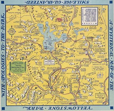
Spokane, WA: Lindgren Brothers, 1948. Pictorial color map [41 cm x 40.5 cm] Linen backed. Near fine. Charming illustrated map showing the auto routes through the park and marking the attractions, including the lakes, geysers, peaks (with elevations) and lodgings. One of two maps the Lindgren's produced of Yellowstone, and although presented in a jokey manner, is surprisingly accurate and useful. "Hatched & scratched by Jolly Lindgren"
The Lindgren brothers of Spokane, Washington, were commercial sign makers through the 1920s, as the economic depression of the 1930s took hold in the once prosperous Pacific Northwest, Jolly Lindgren began (truncated)
The Lindgren brothers of Spokane, Washington, were commercial sign makers through the 1920s, as the economic depression of the 1930s took hold in the once prosperous Pacific Northwest, Jolly Lindgren began (truncated)


