unbound
1764 · Paris
by BELLIN, Jacques Nicolas
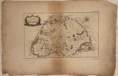
Paris: Jacques Nicolas Bellin, 1764. unbound. Map. Engraving with hand coloring. Image measures 8 1/2" x 13 3/4".
This is a scarce 1764 map of Mauritius by Jacques-Nicolas Bellin, created at the height of French colonial power. Known as Isle de France, Mauritius was a key stop on the East India Trade and a productive agrarian colony under the French East India Company from 1715 to 1810. Oriented with North to the Southwest, the map details inland topography, river courses, and farm grants, alongside coastal features. Forests and mountains are rendered in profile. Port Louis, the island's capital, evolved into a significant port and commercial (truncated)
This is a scarce 1764 map of Mauritius by Jacques-Nicolas Bellin, created at the height of French colonial power. Known as Isle de France, Mauritius was a key stop on the East India Trade and a productive agrarian colony under the French East India Company from 1715 to 1810. Oriented with North to the Southwest, the map details inland topography, river courses, and farm grants, alongside coastal features. Forests and mountains are rendered in profile. Port Louis, the island's capital, evolved into a significant port and commercial (truncated)


