Carousel content with 1 slides.
A carousel is a rotating set of images, rotation stops on keyboard focus on carousel tab controls or hovering the mouse pointer over images. Use the tabs or the previous and next buttons to change the displayed slide.
")
-
 Slide 1:
-
 Slide 2: no title
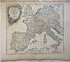
1752
by ROBERT DE VAUGONDY, Didier
1752. Map. Engraving with original hand coloring. Image measures 19" x 22"
Detailed map from 1752 showing Charlemagne's empire. Charlemagne ruled the Carolingian empire from the years 800 to 814. His empire, demarcated with hand colored green outline, included modern-day France, Belgium, Germany, the Netherlands, Switzerland, Austria, northern Italy, northeastern Spain, and the Dalmatian coast. Extends from the Iberian peninsula to the Carpathian Mountains, including the western Mediterranean, the northern coast of Africa, England and Wales. This map is in very good condition. Minor toning and fraying at edges, not affecting the image. One (truncated)
Detailed map from 1752 showing Charlemagne's empire. Charlemagne ruled the Carolingian empire from the years 800 to 814. His empire, demarcated with hand colored green outline, included modern-day France, Belgium, Germany, the Netherlands, Switzerland, Austria, northern Italy, northeastern Spain, and the Dalmatian coast. Extends from the Iberian peninsula to the Carpathian Mountains, including the western Mediterranean, the northern coast of Africa, England and Wales. This map is in very good condition. Minor toning and fraying at edges, not affecting the image. One (truncated)