1680 · Amsterdam
by VAN KEULEN, Johannes
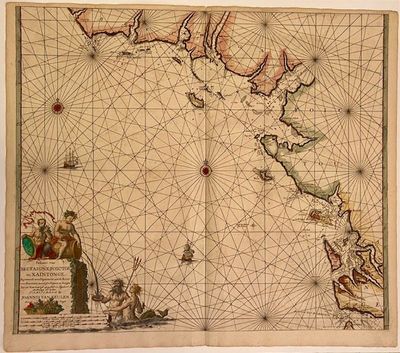
Amsterdam: Johannes Van Keulan, 1680. Sea Chart. Engraving with outline coloring. 19 1/2 x 23".
Beautifully rendered 17th century sea chart of the West Coast of France, from South Brittany, France's northwestern most region, the Loire river entrance down to the North part of Bordeaux. Includes rhumb lines, two compass roses, depths, soundings, nicely detailed banks, and two merchant ships. The Loire river is the longest in France and the gateway to Pouilly-Fume and Sancerre vineyards. Outstanding title cartouche design featuring a barrel of wine being poured out by Bacchus and enjoyed by a Satyr, a merman and a mermaid. A big basket of grapes (truncated)
Beautifully rendered 17th century sea chart of the West Coast of France, from South Brittany, France's northwestern most region, the Loire river entrance down to the North part of Bordeaux. Includes rhumb lines, two compass roses, depths, soundings, nicely detailed banks, and two merchant ships. The Loire river is the longest in France and the gateway to Pouilly-Fume and Sancerre vineyards. Outstanding title cartouche design featuring a barrel of wine being poured out by Bacchus and enjoyed by a Satyr, a merman and a mermaid. A big basket of grapes (truncated)


